US Presidential Election 08
Some months ago I was lucky enough to secure a couple of small contracts with the Obama for America Campaign 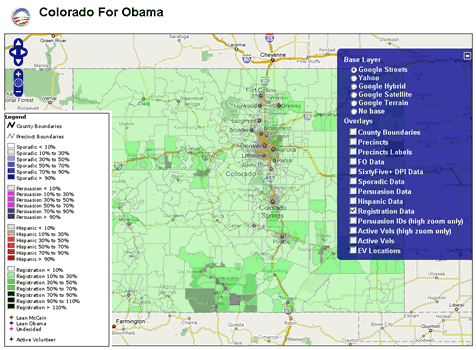 to support their general effort and the work of the field organizers by implementing some web mapping capabilities. After some phone discussions with the Obama Technology team it actually was not hard to convince them to go the open source route and setup a server on Amazon EC2. We took an existing Ubuntu-based server image that included most of the Open Source GIS stack already (many thanks to Josh Livni of Umbrella Consulting who created the public image and who also has instructions on his website on how to set this up quickly: http://os.umbrellaconsulting.com/wiki/AmazonEC2). Continue reading “Obama Campaign – Mapping voters with Mapserver, PostGIS and Openlayers”
Search Results for: -bit.ly/docs/presentations//2008/docs/presentations/CALweedmapper_waurisa_2011.pdf
New Class – Interoperable Web GIS Solutions with Open Source
Terra GIS is offering this 3 day class/hands on workshop in Seattle from December 3rd through Friday December 5th, 2008. Interoperable Web GIS Solutions built on Free and Open Source Geospatial software (FOSS4G) offer very effective means of delivering reliable, modern, standard compliant and flexible solutions. They can be used as stand alone applications or in conjunction with proprietary systems. Especially over the last years FOSS4G have become a viable alternative to proprietary software, and implementing GIS with FOSS helps to meet budget challenges as is outlined in this NASA study: Geospatial Interoperability Return on Investment Study
The main topics of the class/hands on workshop are as follows: Continue reading “New Class – Interoperable Web GIS Solutions with Open Source”
Web GIS Solutions using Open Source Geospatial Software
The talk held by Karsten Vennemann at the 2008 WAURISA Conference in Seattle gave an overview on building web GIS solutions using open source geospatial software components. A selection of the most advanced and popular open source components, their roles and functionalities in an application framework are described. A complete stack for building web GIS solutions can include a client-server application framework, a web mapping engine supporting cartographic rendering functionality and basic GIS capabilities, data storage solutions such as spatial databases, and additional tools extending or enhancing the basic GIS capabilities of the mapping engine. The concept of an interoperable software solution is illustrated by a variety of examples. Web GIS application frameworks are either complete client-server solutions such as MapFish and Mapbender or Web GIS clients such as Open Layers and Ka-Map. Internet mapping engines such as MapServer and GeoServer render images, provide basic GIS functionality and/or provide the functionality for serving Web mapping services (WMS) and Web feature Services (WFS). Using cached and tiled data in a web GIS application can substantially speed up its response time. TileCache is a server and caching solution that can be used for the creation of cached data from WMS. Feature Server provides data conversion of simple features from a variety of input formats into target formats such as GeoJSON and KML and can be used to integrate the framework with additional applications. Spatial databases include solutions such as PostGIS and MySQL. PostGIS itself provides comprehensive GIS capabilities that can greatly extend the mapping engine’s capabilities and simplify execution of geo-processing tasks using spatial SQL. Additional tools can be integrated with the framework to provide specific GIS capabilities. One example for such a tool is the Perl module GeoCoderUS that can provide geocoding for the entire US based on census Tiger Line files.
Download the presentation slides here.
Interactive Web Maps

CALweedmapper
Two web mapping sites have been built for CALIPC (California Invasive Plants Council), a non-profit that is dedicated to protect the natural vegetation and environment of California. The internal web mapping site was designed and built by Terra GIS to enable data entry, dynamic storage and online mapping capabilities for over 200 non-native (invasive) plant species tracked by CALIPC and their partners. CALWeedmapper is the public facing (second) web mapping site, a complex web GIS application that was built for CALIPC in collaboration with CALFLORA and Green Info Networks. The public site features a “basic” (general) user area that allows to display and query over 200 dynamic plant species GIS layers and to create reports on a variety of geographic units (e.g. Counties, Weed Management Areas etc.) . It also includes a log-in area of the web site, which has database editing capabilities for users that obtained a password from CALIPC. Technically the application is based on the open source tools MapServer, PostGIS, and OpenLayers and in addition the JavaScript frameworks ExtJS & GeoExt. View presentation slides (internal tool only) from the presentation at WAURISA 2010 in Tacoma, Washington State, USA.

Nicaragua Projects
A simple but efficient web mapping site of development aid sponsored projects in Nicaragua was built for the Howard G. Buffet Foundation (HGBF) in 2011. The map allows to display and query locations of multiple levels of project partners and organizations alongside with pictures and project & location descriptions of the projects on the ground. Technically the web map is based on MapServer, PostGIS and OpenLayers and was built in a very short time frame (about one week).
A simple but efficient web mapping site of development aid sponsored projects in Nicaragua was built for the Howard G. Buffet Foundation (HGBF) in 2011. The map allows to display and query locations of multiple levels of project partners and organizations alongside with pictures and project & location descriptions of the projects on the ground. Technically the web map is based on MapServer, PostGIS and OpenLayers and was built in a very short time frame (about one week).

VFS Viewer (Verein für Forstliche Standortserkundung – Bavaria Germany). The VFS Viewer project was developed in co-operation with our partner company CSGIS in München (Munich) Germany. The Web GIS was built as a tool for the public and more specifically for private forest owners to determine if their own (forested) property has been mapped by the VFS. The VFS is a non profit organization based in Munich that conducted long term field mapping projects over the last 30 years during which detailed soil and suitability maps where created at a scale of 1:5000 for all private forest areas in the state of Bavaria. The detailed soil and suitability maps are not included in the public version of the viewer due to privacy and copyright issues. However the tool enables all private forest owners to determine by themselves if an area has been mapped and the owner can then directly contact the VFS to obtain information about his property. The project was presented at AGIT 2011 in Salzburg (download slides in German), Austria and a short article published in the conference proceedings ( download article in German).

OCLA GIS
In 2008 a comprehensive project was started to built the Office of Civil Legal Aid GIS – WA State (OCLA GIS). OCLA supports people in WA State that are low income by providing or facilitating access to civil legal aid services. The GIS was built to support strategic planning processes on how to optimally allocate the available resources of OCLA and its partner organizations in regards of the populating in need of civil legal help (project phase 1). In phase two additional capabilities such as query and reporting functionality (maps and database export or reports) was added, a OCLA GIS users guide was developed & published, and technical training for the OCLA partner organizations conducted. In 2011 new census data where added, the technical guide for OCLA GIS completed and additional functionality added to the system. View presentation slides from the presentation at WAURISA 2010 in Tacoma, Washington State, USA.

Ekiti State Infrastructure Viewer
The Ekiti State Infrastructure Viewer was build in co-operation with Ademola Omojola, Professor at the Department of Geography, University of Lagos for the Government of Ekiti State Nigeria. The Web GIS enables to spatially query, display & identify information for a variety of infrastructure & amenity categories for the entire State. Roads and land use base layers form the background information along with LGA district boundaries. Google satellite and aerial imagery is available in a decent resolution and quality for Ekiti State and can be viewed as an alternative background layer in the web GIS viewer. Infrastructure features are provided in fourteen categories such as education, health and telecommunication and can be individually selected, viewed and identified, including pictures for most of the features.

US Geocoder – for Online Image
Terra GIS supported the work on the US Geocoder site that includes US wide data & maps, enables users to geocode street addresses in the entire US, calibrate geocoding results via client input, to find legislative districts and elected officials and much more. The project was developed in collaboration with Robert Hollingsworth of Kartanica Geosystems for Online Image. Cartography of the maps, reverse geocoding alongside with the mapping user interface was part of Terra GIS’s tasks in the project.

Obama for America Campaign Web GIS
( project for the 2008 US election, not online any more ) During the 2008 US election Karsten Vennemann of Terra GIS created an Open Source based web mapping site for the Obama campaign to support their general efforts and to map voters in a dozen battle ground states. Read more about the project in the article Obama Campaign – Mapping voters with Mapserver, PostGIS and Openlayers online. Download published articles: The US Election 2008 – Karsten Vennemann looks at mapping voters for the Obama Campaign with MapServer, PostGIS and OpenLayers Geoconnection magazine 3/2009 and “A Map For Change” read online or download as pdf
.

Montana Rivers and Climate Change GIS
The web mapping site for American Rivers and Pacific Rivers Council supports grass roots organizing and advocacy work for research and non-profit groups working in the State of Montana. GIS data include information regarding Montana rivers such as ‘Wild and Scenic Rivers‘, ‘ Dewatered Streams‘, ‘Habitat and Species Value’, ‘ Aquatic Integrity Areas‘, ‘ NWPPC Protected rivers‘, along with base layers such as ‘Watershed boundaries’, ‘Hydro power Dams’, infrastructure features and ‘public & protected lands’. Technically the application is based on the MapBender web mapping framework, and web map services published via the MapServer mapping engine.
Spatial Tools
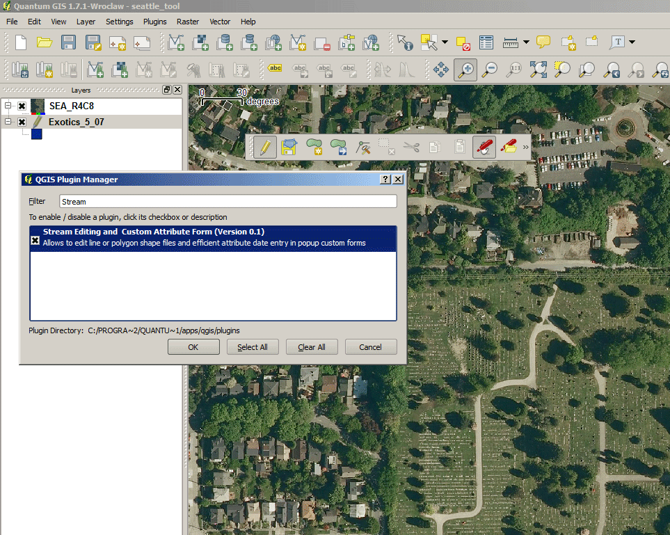 |
Stream Editing and Custom Attribute Form “Tool” To enable a flexible way to collect data in the field a python plugin for QGIS (a free open source desktop software program) was developed based on an already existing stream digitizing tool.. |
|
| The custom plugin enabled field staff of “Shelterbeltbuilders” (an open land management and restoration company in San Francisco) to quickly adapt custom attribute data collection entry forms and to streamline data entry by using pre-populated drop down fields without complicated configuration work. The plugin supports the creation of custom (user defined) forms for data entry via creating a simple MS Excel spreadsheet, stream digitizing for use on tablet computers in the field (e.g. location and sperad of invasive species), and supports quick attribute data collection (via the custom forms). Using the tool the time needed for field data collection was cut down from a couple of weeks anticipated to several days. Let us know what you might be looking for. | ||
 |
Matching information to member records Do you have data records, such as member or address lists that you would like to complement with additional spatial data? |
|
| Would you like to know the geographical distribution of address records in your member or customer database? In all those cases we can help. The example on the left shows a screen shot of a web based tool for automatically matching spatial information such as County, City, School District, Congressional District and Voting District to address files (e.g. member lists containing street addresses can be used). With minimal effort this tool can be customized to match any other spatial information. For more information read  about the tool we built for Washington Conservation Voters Education Fund an article on online list matching about the tool we built for Washington Conservation Voters Education Fund an article on online list matching |
||
Cartography and Analysis
| Most Endangered Rivers of the USA – American Rivers | ||||
| A map series showing the ten most endangered Rivers in the USA was published by American Rivers for their 2010 campaign. On the American Rivers website the report was announced as follows: | 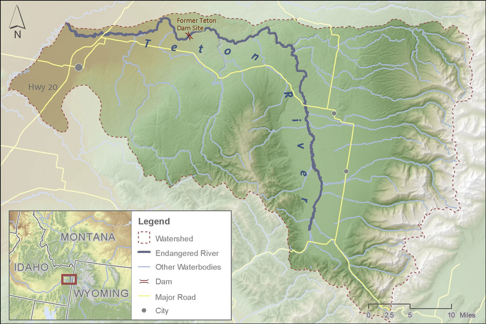 |
|||
| “American Rivers today released its most anticipated report of the year, America’s Most Endangered Rivers of 2010. The 25th anniversary edition of the report spotlights ten rivers facing the most urgent threats, and also features key endangered river success stories from the past two decades.” | ||||
| Antarctica Satellite Image Slides – 2041 | ||||
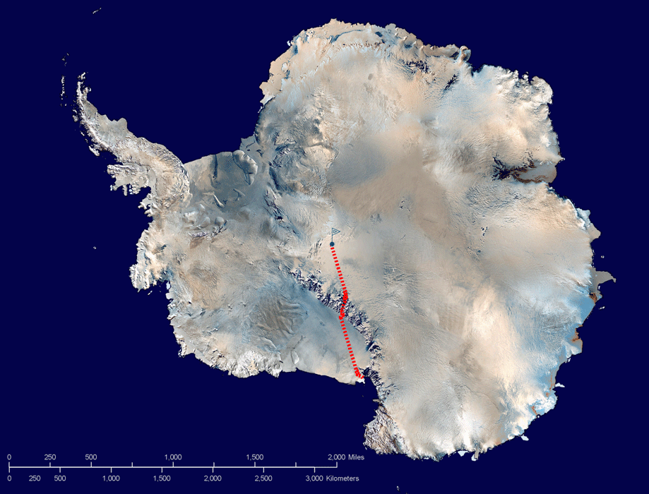 |
This set of slides where done for British Explorer and Global Environmental Activist Robert Swan and his non-profit organization 2041 to help promote his 2012 expedition. Robert Swan is the first person who walked to both poles, South and North. | |||
| Twentyfive years after he reached the South pole and 100 years after Amundson and Scott he is planning another expedition called ‘the return journey 2012’: to reach the edge of the Antarctic continent starting from the South Pole (the opposite way he went 25 years ago) – this time without using any fossil fuels. Read more about the great work of 2041. | ||||
| Global Warming Scenario for the Pacific NW of the USA – American Rivers | ||||
| This map for American Rivers shows Global Warming Scenarios for the Columbia River Basin in the Pacific NW of the USA. The data used for the map are from the Climate Impacts group of the University of Washington (2007). |  |
|||
| The main map shows the potential warming for the year 2070 and the inset map shows the August mean Surface temperatures averages for 1980 – 1997. The main goal of the map was to visualize the potential temperature changes in salmon habitats throughout the Columbia River Basin. | ||||
| Hydropower Dams Licensing – Hydropower Reform Coalition | ||||
 |
Hydropower dam re-licensing represents an important opportunity for river restoration. This map series is about hydropower dams and related licensing information. The maps classify FERC (Federal Energy Regulatory Commission) regulated dams into several categories, such as exempt from licensing, recently licensed, and imminent or future opportunity (depending on the year when the license expires). The maps visualize location, project and licensing information in a way | |||
| that allows the Hydropower Reform Coalition to plan for current, near term and future opportunities to take action regarding the issuance of new licenses, and related mitigation & restoration measures. |  |
|||
| The first maps of the series where created at CommEn Space, the last ones completed by Terra GIS. Currently 4 maps including California, US Pacific Northwest, US Southeast, and Hydropower Dams Rockies have been completed. | ||||
 |
A pilot study by Terra GIS illustrates the integration of the map data into a hydropower web mapping application for use as a dynamic information system. | |||
| Easel Map Display for the Shorewatch Program – People for Puget Sound | |||
 |
Shorewatch is one of PPS’s outreach and education programs to build community awareness of conservation issues around Puget Sound. A set of maps was created as a basis for an easel display that is used for outreach and education activities by PPS staff. The series of three maps was created by Karsten Vennemann at CommEn Space, showing the area of Puget Sound and neighboring watersheds (catchment basins). | ||
| Two of the poster size maps (4 by 4 feet) where printed by a third party print shop onto the metal surface of an transportable easel display. One side of the easel is showing the topography of Puget Sound and its hydrologic features. The opposite site of the board shows the watersheds around Puget Sound. |  |
||
 |
The third map was used to create and cut flexible magnetic jigsaw puzzle pieces that can be used in educational outreach activities. The puzzle | ||
| pieces can be stuck onto the easel as an educational activity, virtually recreating the Puget Sound watershed. | 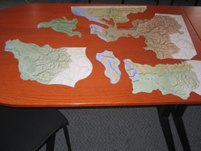 |
||
| The Wenatchee Watershed Vision – The Trust for Public Land | |||||
 |
The Wenatchee Watershed Vision is a conservation vision plan for the Wenatchee River Watershed. The main focus is on the areas stretching from Leavenworth to Wenatchee. The report includes 16 maps that were created by Matt Stevenson (CoreGIS), Karsten Vennemann (now Terra GIS) and Erica Simek (now The Nature Conservancy). | ||||
| All maps shown here where created by Karsten Vennemann of Terra GIS. Base maps in the report include public and protected lands, working lands and recreation. |  |
||||
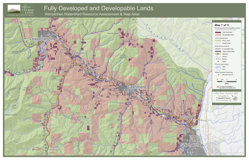 |
One part of the report is about evaluation of future housing developments. The maps to the left show part of the results of an comprehensive analysis that included analysis of developed, divisible & developable lands, and modeling of maximum potential development that likely will be affected the most by future housing developments. | ||||
| The maps to the right illustrate easements for public fishing access on private parcels along the Wenatchee River. Until recently restrictions on fishing have been in place. Read more about the report here. |  |
||||
More sample maps
 |
Salmon-Safe Certified Farms – Stewardship Partners Salmon – Safe is an eco-label certification program that evaluates farms regarding their adoption of fish-friendly conservation practices and participation in salmon habitat restoration. The base for this web click-able map was created by Karsten Vennemann at CommEn Space. |
|
 |
Alaska – Satellite Image map Example for a map using satellite imagery and transparent vector overlays. |
|
 |
Protected Lands – Pacific Coast Joint Venture The map shows protected lands in 1990 and 2006 in and around Grays Harbor on the Washington coast. |
|
The Trust for Public Land publishes “Wenatchee Watershed Vision” Report
TPL’s Northwest Regional Office recently published “The Wenatchee Watershed Vision” including maps by Karsten Vennemann of Terra GIS. The report was completed in September 2007 and is a conservation vision plan for the Wenatchee River Watershed. The main focus is on the areas stretching from Leavenworth to Wenatchee. It is intended to serve as inspiration for community action, fostering coalitions, strategic partnerships and cooperation among local government agencies, and public and private entities in the area. Continue reading “The Trust for Public Land publishes “Wenatchee Watershed Vision” Report”
Staff

Karsten Vennemann
Principal and GIS Analyst
Karsten is the principal scientist and GIS Analyst at Terra GIS. He has over 20 years of expertise in environmental evaluation and GIS. His background is in Geography and Soil Science and he holds a Diploma from the University of Stuttgart, Germany, and a Master’s Degree from UC Berkeley. His previous work included positions as Environmental Scientist, GIS Analyst and Programmer, and Project Coordinator.
CV – K. Vennemann
Work Experience |
||
| since 1/07 | Terra GIS LTD, Seattle, WA – USA | |
| Principal and GIS Analyst. Terra GIS provides services in cartography, data processing, spatial analysis, spatial databases, GIS programming, web mapping, GIS training and environmental consulting. Our main focus is on maps and services in environmental and conservation GIS, spatial analysis, scientific research and sustainable development. | ||
| 8/05 – 12/06 | CommEn Space (The Community & Environment Spatial Analysis Center), Seattle, WA – USA | |
| GIS Analyst and project manager. Primary tasks included cartography and GIS analysis (e.g. for conservation planning and prioritization), coding of scripts for desktop use (VB and Arc Objects) and development of web-mapping applications (e.g. database access for web mapping applications), and project management. Provided ongoing technical support to other GIS staff and researched newest technologies to advance CommEn Space’s GIS knowledge and resources. | ||
| 10/04 – 7/05 | SAIC (Science Applications International Cooperation), Bothell, WA – USA | |
| Environmental Scientist and GIS Specialist. GIS services, aerial photo interpretation (land use interpretation) and mapping. Consultant in soil and groundwater remediation projects. Consultant for solid waste recycling projects for King County. | ||
| 8/01 – 10/03 | University of Stuttgart, Germany Department of Landscape Architecture and Ecology |
|
| GIS-expert and specialist in environmental planning and soil conservation. Leading GIS specialist for the “gimolus” project (Development of web based e-learning modules for environmental studies). Development and management of the geodatabase. Programming of GIS functions (ArcObjects) and coupling with model based calculations. Setup and maintenance of the web servers and web based GIS. Consulting and training of other employees in GIS. | ||
| 6/00 – 7/01 | GEF-RIS Inc., Leimen, Germany | |
| GIS consultant and programmer. Providing consulting and training to customers. Programming of GIS modules such as water supply and environmental management using a macro language. Participation in the conceptional development and advancement of GIS functionality of the software | ||
| 4/98 – 4/00 | University of Hohenheim, Germany, Department of Soil Science and Land Evaluation |
|
| GIS analyst and assistant project coordinator: Editing and coordination of the digital “Atlas of natural and agronomic resources of Niger and Benin” (West Africa). Created GIS based maps, database and the web site presentation. Instructor for Geography and GIS seminars for visiting scientists of cooperating organizations from Benin. Feasibility survey for the “Map of natural heavy metal content in soils of southern Germany” (State environmental protection agency) | ||
| 9/97 – 8/98 | Institute for Environmental Remediation and Protection, Inc. Leonberg, Germany |
|
| Consultant in soil and groundwater remediation projects. Including field work for surveying, sampling, analysis and remediation of contaminated sites (industrial sites, gas stations, waste disposal sites, etc.) | ||
| 1/96 – 6/97 | University of California at Berkeley, USA Department of Environmental Science, Policy and Management |
|
| Research assistant in water use efficiency in soils: investigation on the impact of different kinds of organic compost on water use efficiency in agricultural soils. Teaching assistant for the course “Soils and their significance to society” | ||
| 9/95 – 12/95 | University of Stuttgart, Germany Department ofHydraulic Engineering and WaterManagement |
|
| Research assistant: research study on steadiness of extreme discharge events of 13 streams in southwestern Germany. Evaluation of change in extreme discharge events over 80 years and its relation to climate change and urbanization | ||
| 9/95 – 10/95 | Historic Buildings and Monuments Commission (Landesdenkmalamt Baden-Württemberg) , Stuttgart, Germany | |
| Assistant in the archeological excavation of the medieval village of “Vöhingen”: Excavation, registration, documentation, surveying and mapping of medieval findings | ||
| 1991 – 94 | State Geological Survey (Geologisches Landesamt Baden-Württemberg), Freiburg,Germany | |
| Research assistant: field mapping of soils (1:25000 soil maps). Identification, classification and evaluation of soils. (Multiple appointments: 6/94-10/94; 5/93-7/93; 5/91-7/91) | ||
| 10/93 – 2/94 | University of Stuttgart, Germany, Geography Department | |
| Teaching assistant for graduate level soil mapping class (field) | ||
| 9/93 | University of Hohenheim, Germany, Department of Soil Science and Land Evaluation |
|
| Research assistant: field mapping of soils in an urban center (soil map of Stuttgart) | ||
| 8/93 | Institute for Land And Water Management (Instituut voor Land en Waterbeheer), Leuven, Belgium | |
| Intern: worked in landscape planning for a structural plan of Vlandern (1:100000) using air photos and GIS | ||
| 5/92 – 9/92 | Society for Regional Planning and Ecology, Inc. (Planungsgesellschaft für Raumordnung und Oekologie), Karlsruhe, Germany | |
| Intern: assisted in mapping and evaluating biotopes and vegetation in the field for landscape planning and environmental impact assessment | ||
| 10/91 – 2/92 | University of Stuttgart, Germany, Geography Department | |
| Research Assistant at the Soil Science Laboratory (research on Spitzbergen and Namibia) | ||
Education |
||
| University of California at Berkeley, Master of Science in Soil Science, May, 1997 | ||
| Emphasis: | Soil and environmental evaluation, agro-ecology, sustainable development ,GIS | |
| University of Stuttgart, Germany, Master of Science in Geography, February 1995 | ||
| Emphasis: | Impact of human activities on natural environments, land use planning, environmental evaluation, geo-ecology | |
| Minors in | Geology, Soil Science, Landscape and Vegetation Ecology | |
Social Service |
||
| 11/87 – 6/89 | Municipal Hospital, Sindelfingen, Germany | |
| Worked as a nurse assistant on a surgery ward. Helped care for pre- and post- surgery patients | ||
Computer Skills |
||
| GIS/maps | QGIS, gvSIG, ArcGIS 10+9+8.X, MapServer, GeoServer, OpenLayers, Leaflet, MapBender, Geomoose | |
| Databases | PostgreSQL, PostGIS, MySQL, Oracle, SqlServer, MS Access,SQL | |
| Graphics | Photoshop, GIMP, Inkscape, Illustrator | |
| Webpages | HTML, CSS, Java Script, JQuery, PHP, Python | |
| Other | Libre Office, MS Office, Win10/ 8/ 7,Linux, Visual Basic, Bash, Microstation J, IDRISI, AML, ArcObjects | |
Language Proficiency Skills |
||||
| English | fluent | (second language, 9 years in school, lived 2 years in California, living in Seattle since 2003) | ||
| German | perfect | (native language) | ||
| French | good | (5 years in school, multiple stays in France and french speaking African countries ) | ||
| Spanish | good | (5 years in school, multiple stays in Spain and South America) | ||
Further Interests |
||||
| Basketball, Cycling, back country skiing, hiking, and photography | ||||
References
Recent/Current clients
- Obama Campaign (Obama for America Inc.)
- Washington State Bar Association
- Beam Reach ( Marine Science and Sustainability School )
- Berk & Associates
- Sierra Club
- Robert Swan – 2041
- CSGIS
-
VFS WEB GIS viewer für den Verein für Forstliche Standortskartierung München, Germany
- Jagdkataster Web GIS Bayrischer Bauernverband München, Germany
-
- AppOven, Portland Oregon
- Pacific Rivers Council
- Save our Wild Salmon Coalition
- Polad Technologies, Lagos Nigeria – Project for Ekiti State WEB GIS
- Stewardship Partners
- Washington State Office of Civil Legal Aid
- CPH Consulting
- Floyd|Snider
- Online Image
- American Rivers
- Peterson GIS
- Core GIS
- Newfields
- Sound Data Management
- RIC International Inc.
- Justice Alliance Education Fund
- Sound Alliance
- Catalist
- Hydropower Coalition
- Washington Conservation Voters Education Fund
- Washington Environmental Council Voter Education Program
- Great Peninsula Conservancy
- Cascade Land Conservancy (now Forterra)
- California Invasive Plant Council
- Calweedmapper internal and public Web GIS sites
- Whippet weed heuristics Web GIS
- Howard G. Buffet Foundation
- Shelterbelt Builders Inc, Berkeley
- Catholic Relief Services – Latin America
- Geospatial Partners – Web based Image Processing System
- Dr-i-ve – Data management for Google Earth using GeoServer/ PostGIS
- Open Urban
- Trident Seafood
- Mayors Against Illegal Guns
- University of Hohenheim, Germany, Department of Soil Science and Land Evaluation
- Trans-SEC : Innovating Strategies to safeguard Food Security using Technology and Knowledge Transfer
- McKnight Foundation, CCRP program