CALweedmapper
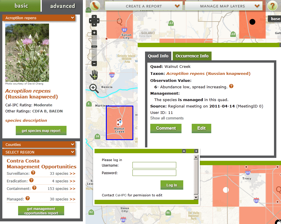
Two web mapping sites have been built for CALIPC (California Invasive Plants Council), a non-profit that is dedicated to protect the natural vegetation and environment of California. The internal web mapping site was designed and built by Terra GIS to enable data entry, dynamic storage and online mapping capabilities for over 200 non-native (invasive) plant species tracked by CALIPC and their partners. CALWeedmapper is the public facing (second) web mapping site, a complex web GIS application that was built for CALIPC in collaboration with CALFLORA and Green Info Networks. The public site features a “basic” (general) user area that allows to display and query over 200 dynamic plant species GIS layers and to create reports on a variety of geographic units (e.g. Counties, Weed Management Areas etc.) . It also includes a log-in area of the web site, which has database editing capabilities for users that obtained a password from CALIPC. Technically the application is based on the open source tools MapServer, PostGIS, and OpenLayers and in addition the JavaScript frameworks ExtJS & GeoExt. View presentation slides (internal tool only) from the presentation at WAURISA 2010 in Tacoma, Washington State, USA.
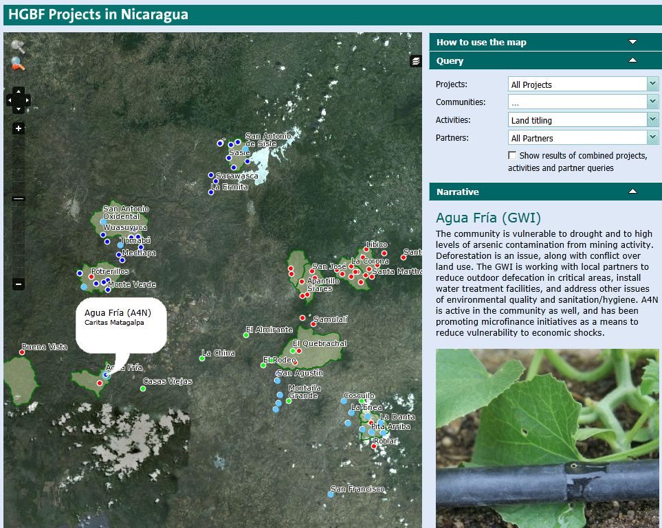
A simple but efficient web mapping site of development aid sponsored projects in Nicaragua was built for the Howard G. Buffet Foundation (HGBF) in 2011. The map allows to display and query locations of multiple levels of project partners and organizations alongside with pictures and project & location descriptions of the projects on the ground. Technically the web map is based on MapServer, PostGIS and OpenLayers and was built in a very short time frame (about one week).
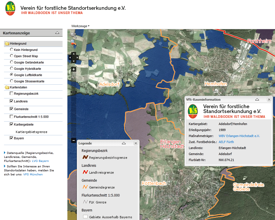
VFS Viewer (Verein für Forstliche Standortserkundung – Bavaria Germany). The VFS Viewer project was developed in co-operation with our partner company CSGIS in München (Munich) Germany. The Web GIS was built as a tool for the public and more specifically for private forest owners to determine if their own (forested) property has been mapped by the VFS. The VFS is a non profit organization based in Munich that conducted long term field mapping projects over the last 30 years during which detailed soil and suitability maps where created at a scale of 1:5000 for all private forest areas in the state of Bavaria. The detailed soil and suitability maps are not included in the public version of the viewer due to privacy and copyright issues. However the tool enables all private forest owners to determine by themselves if an area has been mapped and the owner can then directly contact the VFS to obtain information about his property. The project was presented at AGIT 2011 in Salzburg (download slides in German), Austria and a short article published in the conference proceedings ( download article in German).
OCLA GIS
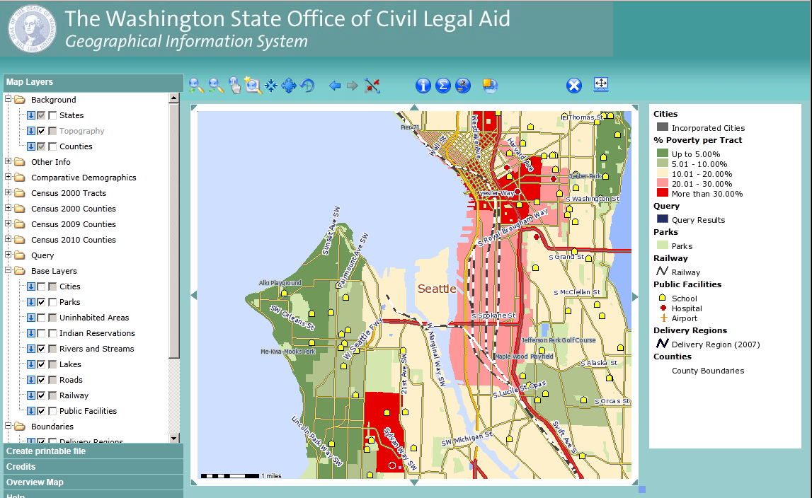
In 2008 a comprehensive project was started to built the Office of Civil Legal Aid GIS – WA State (OCLA GIS). OCLA supports people in WA State that are low income by providing or facilitating access to civil legal aid services. The GIS was built to support strategic planning processes on how to optimally allocate the available resources of OCLA and its partner organizations in regards of the populating in need of civil legal help (project phase 1). In phase two additional capabilities such as query and reporting functionality (maps and database export or reports) was added, a OCLA GIS users guide was developed & published, and technical training for the OCLA partner organizations conducted. In 2011 new census data where added, the technical guide for OCLA GIS completed and additional functionality added to the system. View presentation slides from the presentation at WAURISA 2010 in Tacoma, Washington State, USA.

Ekiti State Infrastructure Viewer
The Ekiti State Infrastructure Viewer was build in co-operation with Ademola Omojola, Professor at the Department of Geography, University of Lagos for the Government of Ekiti State Nigeria. The Web GIS enables to spatially query, display & identify information for a variety of infrastructure & amenity categories for the entire State. Roads and land use base layers form the background information along with LGA district boundaries. Google satellite and aerial imagery is available in a decent resolution and quality for Ekiti State and can be viewed as an alternative background layer in the web GIS viewer. Infrastructure features are provided in fourteen categories such as education, health and telecommunication and can be individually selected, viewed and identified, including pictures for most of the features.
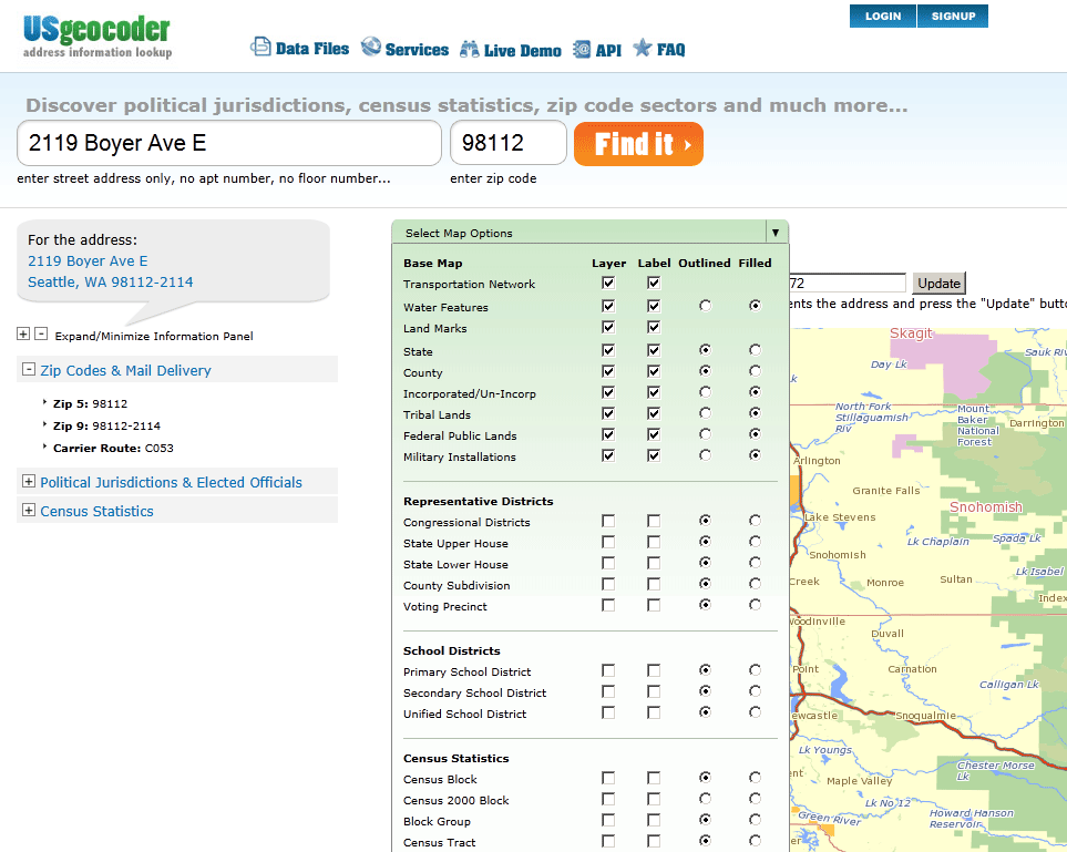
US Geocoder – for Online Image
Terra GIS supported the work on the US Geocoder site that includes US wide data & maps, enables users to geocode street addresses in the entire US, calibrate geocoding results via client input, to find legislative districts and elected officials and much more. The project was developed in collaboration with Robert Hollingsworth of Kartanica Geosystems for Online Image. Cartography of the maps, reverse geocoding alongside with the mapping user interface was part of Terra GIS’s tasks in the project.
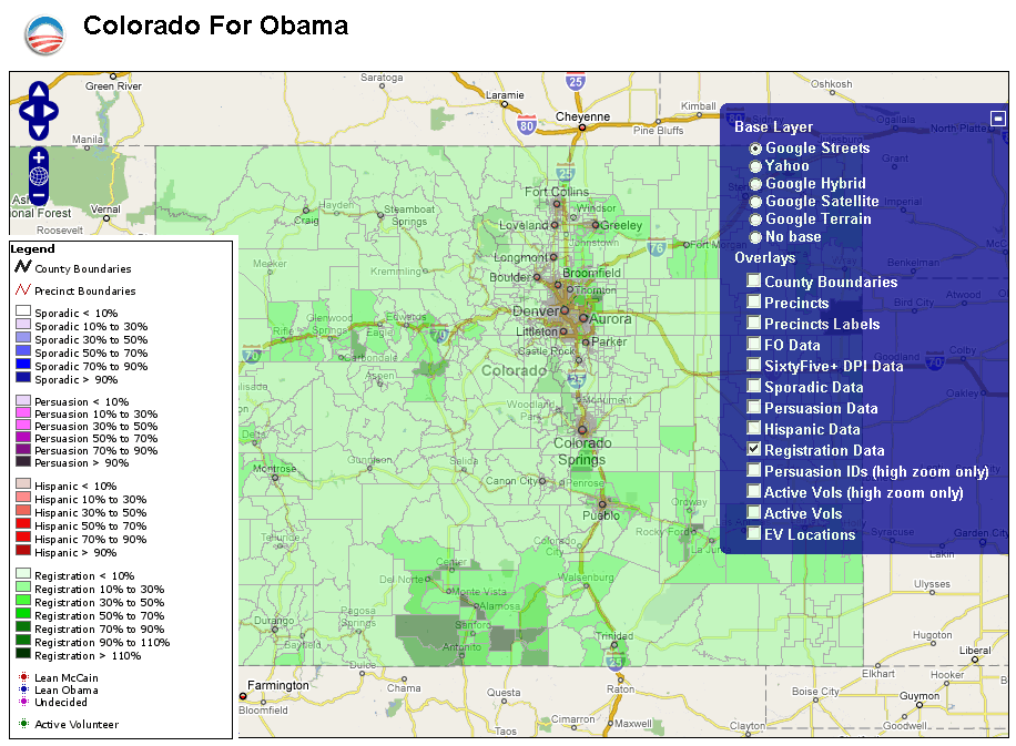
Obama for America Campaign Web GIS
( project for the 2008 US election, not online any more ) During the 2008 US election Karsten Vennemann of Terra GIS created an Open Source based web mapping site for the Obama campaign to support their general efforts and to map voters in a dozen battle ground states. Read more about the project in the article Obama Campaign – Mapping voters with Mapserver, PostGIS and Openlayers online. Download published articles: The US Election 2008 – Karsten Vennemann looks at mapping voters for the Obama Campaign with MapServer, PostGIS and OpenLayers Geoconnection magazine 3/2009 and “A Map For Change” read online or download as pdf
.

Montana Rivers and Climate Change GIS
The web mapping site for American Rivers and Pacific Rivers Council supports grass roots organizing and advocacy work for research and non-profit groups working in the State of Montana. GIS data include information regarding Montana rivers such as ‘Wild and Scenic Rivers‘, ‘ Dewatered Streams‘, ‘Habitat and Species Value’, ‘ Aquatic Integrity Areas‘, ‘ NWPPC Protected rivers‘, along with base layers such as ‘Watershed boundaries’, ‘Hydro power Dams’, infrastructure features and ‘public & protected lands’. Technically the application is based on the MapBender web mapping framework, and web map services published via the MapServer mapping engine.