Karsten Vennemann of TerraGIS will be presenting a 25 minute talk about Open Source Spatial Databases at FOSS4G 2010 in Barcelona (September 6th – 9th 2010).  More than 1200 participants are expected to join this years conference. There will be more than 120 oral presentations during the conference. The abstracts have been posted online including my talk BEYOND POSTGIS – NEW DEVELOPMENTS IN OPEN SOURCE SPATIAL DATABASES. Join me and over 1000 other Open Source GIS friends in Barcelona at this exciting event!
Download my presentation
News/Articles
Open Source Desktop GIS Workshop at WAURISA 2010
TerraGIS will be presenting a half day “pre-conference” workshop on April 19th 2010 at the WAURISA 2010 conference. This years slogan is “rise to the challenge”. The conference is held from April 19th-21th, 2010 in the Greater Tacoma Convention & Trade Center , 1500 Broadway, Tacoma, Washington, USA.
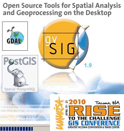 This time I will be talking about “Open Source Tools for Spatial Analysis and Geoprocessing on the Desktop“. A general introduction and overview about the tools covered in this workshop will be followed by examples illustrating the use of desktop utilities based on the OGR/GDAL2 libraries, PostGIS (“the” open source spatial database) and gvSIG (a desktop GIS) for spatial analysis and geoprocessing. During the workshop participants can use a live DVD with their own laptop to go along with some of the exercises. Continue reading “Open Source Desktop GIS Workshop at WAURISA 2010”
Unlocking data trapped in mdb files – on Linux
I thought this a nice title for this short post about getting your data out of MS Access files on Linux.
Some weeks ago I had the task to get a schema of the US census summary files into PostgreSQL to subsequently being able to load the entire US data for those summary files (SF1 and SF3).
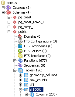
After some searching on the web I found schemas for those summary files in Access mdb format (SF1 template and SF3 template). Many of the tables in the summary files have well over 100 columns (see screen shoot in pgAdmin on the left hand side) and there are more than 200 tables for both summary files combined. So that was definitely not a quick “punch-the-table-schema-in-quickly” job to recreate the tables in PostgreSQL. Again searching on the web I stumbled about this post mentioning the excellent mdbtools. Great – just the right tool found in time. Since the server where the work is supposed to happen runs Ubuntu there was even no need to compile the mdb tools program at all.
After installing mdb tools via
sudo apt-get install mdb-schema
I could easily export the schemas from the SF1and SF3 mdb files as SQL statements:
mdb-schema -S sf1.mdb postgres > sf1.sql
sudo apt-get install mdb-schema
I could easily export the schemas from the SF1and SF3 mdb files as SQL statements:
mdb-schema -S sf1.mdb postgres > sf1.sql
After running the sql files I had the schemas loaded in almost no time. On this blog there is even a python program using the mdb tools that allows you to directly extract data from mdb files into csv format – sweet.
Have fun unlocking your data !
Obama Campaign – Mapping voters with Mapserver, PostGIS and Openlayers
US Presidential Election 08
Some months ago I was lucky enough to secure a couple of small contracts with the Obama for America Campaign 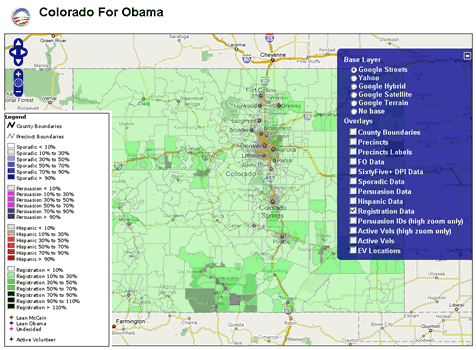 to support their general effort and the work of the field organizers by implementing some web mapping capabilities. After some phone discussions with the Obama Technology team it actually was not hard to convince them to go the open source route and setup a server on Amazon EC2. We took an existing Ubuntu-based server image that included most of the Open Source GIS stack already (many thanks to Josh Livni of Umbrella Consulting who created the public image and who also has instructions on his website on how to set this up quickly: http://os.umbrellaconsulting.com/wiki/AmazonEC2). Continue reading “Obama Campaign – Mapping voters with Mapserver, PostGIS and Openlayers”
New Class – Interoperable Web GIS Solutions with Open Source
Terra GIS is offering this 3 day class/hands on workshop in Seattle from December 3rd through Friday December 5th, 2008. Interoperable Web GIS Solutions built on Free and Open Source Geospatial software (FOSS4G) offer very effective means of delivering reliable, modern, standard compliant and flexible solutions. They can be used as stand alone applications or in conjunction with proprietary systems. Especially over the last years FOSS4G have become a viable alternative to proprietary software, and implementing GIS with FOSS helps to meet budget challenges as is outlined in this NASA study: Geospatial Interoperability Return on Investment Study
The main topics of the class/hands on workshop are as follows: Continue reading “New Class – Interoperable Web GIS Solutions with Open Source”
Web GIS Solutions using Open Source Geospatial Software
The talk held by Karsten Vennemann at the 2008 WAURISA Conference in Seattle gave an overview on building web GIS solutions using open source geospatial software components. A selection of the most advanced and popular open source components, their roles and functionalities in an application framework are described. A complete stack for building web GIS solutions can include a client-server application framework, a web mapping engine supporting cartographic rendering functionality and basic GIS capabilities, data storage solutions such as spatial databases, and additional tools extending or enhancing the basic GIS capabilities of the mapping engine. The concept of an interoperable software solution is illustrated by a variety of examples. Web GIS application frameworks are either complete client-server solutions such as MapFish and Mapbender or Web GIS clients such as Open Layers and Ka-Map. Internet mapping engines such as MapServer and GeoServer render images, provide basic GIS functionality and/or provide the functionality for serving Web mapping services (WMS) and Web feature Services (WFS). Using cached and tiled data in a web GIS application can substantially speed up its response time. TileCache is a server and caching solution that can be used for the creation of cached data from WMS. Feature Server provides data conversion of simple features from a variety of input formats into target formats such as GeoJSON and KML and can be used to integrate the framework with additional applications. Spatial databases include solutions such as PostGIS and MySQL. PostGIS itself provides comprehensive GIS capabilities that can greatly extend the mapping engine’s capabilities and simplify execution of geo-processing tasks using spatial SQL. Additional tools can be integrated with the framework to provide specific GIS capabilities. One example for such a tool is the Perl module GeoCoderUS that can provide geocoding for the entire US based on census Tiger Line files.
Download the presentation slides here.
The Trust for Public Land publishes “Wenatchee Watershed Vision” Report
TPL’s Northwest Regional Office recently published “The Wenatchee Watershed Vision” including maps by Karsten Vennemann of Terra GIS. The report was completed in September 2007 and is a conservation vision plan for the Wenatchee River Watershed. The main focus is on the areas stretching from Leavenworth to Wenatchee. It is intended to serve as inspiration for community action, fostering coalitions, strategic partnerships and cooperation among local government agencies, and public and private entities in the area. Continue reading “The Trust for Public Land publishes “Wenatchee Watershed Vision” Report”
ONEList features list matching tool
July’s edition of ONENORTHWEST’s newsletter “ONEList” features a brief article about our member list matching tool. Karsten Vennemann started implementing the tool at CommEn space and continued the development and support of the tool after the creation of Terra GIS. This is an extract from the article:
“Our friends at CommEn Space recently released a prototype version of an online list enhancement tool that can provide the legislative district (LD) number and county name for the addresses of your membership and prospect lists.
Washington Conservation Voters Education Fund (WCV Ed Fund) and their Priorities for a Healthy Washington coalition partners use the tool to automatically add the LD number and county name to lists of up to 1000 addresses at once… “
Terra GIS presents online list matching tool at the WA URISA Conference
[english]
The WA URISA Conference was held April 23-25th, 2007 in
Most commercial GIS desktop software includes tools to spatially join information to a location. A spatial join operation adds information based on the geographical location of one feature to another. This talk illustrates how to build an online tool that can perform spatial joins using open source software. The technical solution presented can support any type of spatial join based on street address and a polygon layer and can be run on both Windows and Linux server platforms. For simplicity we will focus on providing a technical overview on how a web based tool can allow users with little or no GIS knowledge to attach legal district information for
For more information about this tool please contact us. You can download the presentation slides here.
[/english]
[german]Ist der Titel des Vortags den Karsten Vennemann anlaesslich der WA URISA Konferenz in
Download the presentation slides here.[/german]
[french]mais qui.[/french]
[spanish]claro que si.[/spanish]